
The loud, but miniscule coqui frog

Parks like this abound in Hilo

Rainbow Falls - just on the outskirts of Hilo

Banyon captive - a la "Lost" - seen any polar bears?
We rented a car again and went back to the Volcanoes National Park to do some hiking. We walked the four-mile Mauna Iki Trail which took us around the rim of a volcanic crater before descending into it. After crossing the solidified lava lake, we ascended the other side to the Thurston Lava Tube before returning to the trail head. 
Trail head interpretive sign

Walking along the rim of the crater

Walking across the hardened lava "lake"

View of the crater from the trail head

Forested path along the rim

Where Pele lives

Path across the devestated lava "lake"
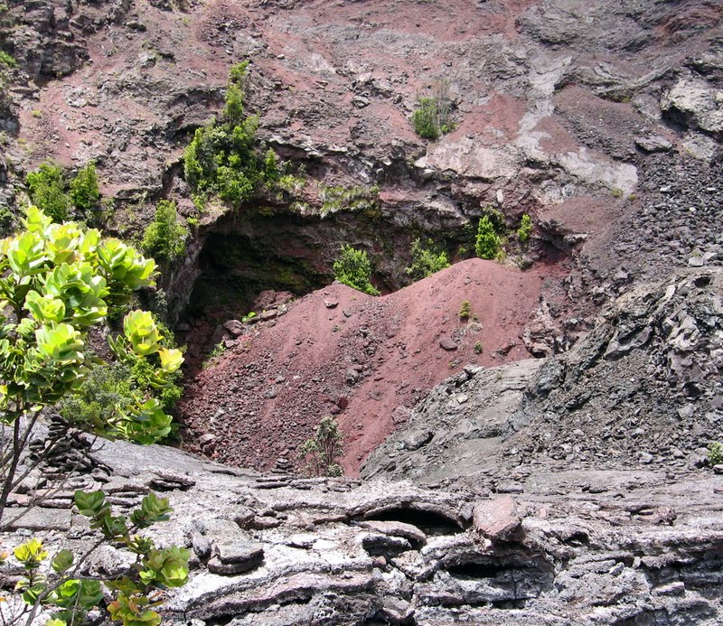
Eruption hole - notice how quickly nature re-asserts herself

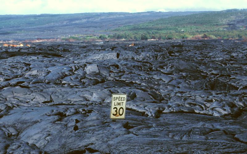
Lava rock eruptions that look a lot like asphalt

Hopeful re-growth in a harsh environment

Ascending the slope of the crater


Entrance to the Lava Tube

Inside the tube - it continued another 350+ meters past the lighted area
Afterward, we drove 19 miles along Chain of Craters Road to the sea. To say it was spectacular would be a massive understatement as it descends thousands of feet through lush forest, craters, and lava fields before reaching a churning, windswept sea.

Driving down the "bench"

Hardened lava flows - Mauna Loa in the distance

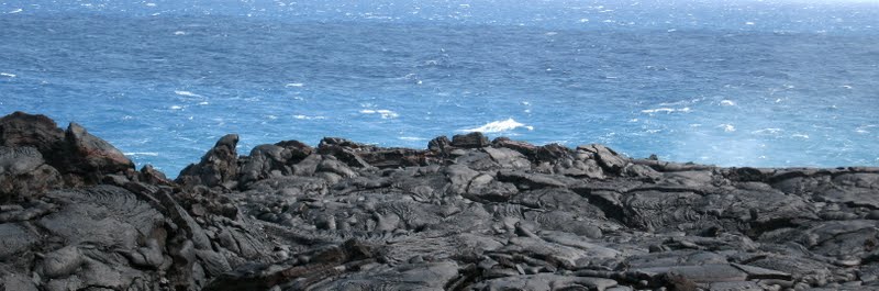
Rough coastline
We had lunch at the Kealakomo Lookout where we could see the full extent of Mauna Loa to the north, the south point of the Big Island in the distance, the volcanic bench and rocky cliffs bordering the turquoise ocean tossing up huge plumes of spray, to the coiling lava beds obstructing the road to the east.

Coiling lava beds

End of the Road

An understatement
As we looked south, into the white caps tossed up by the strong winds, we imagined the new island of Lo’ihi rising up beneath the waves.
Looking out toward Lo'ihi
We learned the south coast used to be populated but, today, the only evidence of the inhabitants is the Pu’u Loa Petroglyphs. They can be viewed by walking half a mile across a slowly rejuvenating landscape in an area that is still considered a sacred place by the Hawaiian people.

Sign at the trail head

An ancient path winds itself into the landscape

Petroglyphs

Ritual of the umbilical cord (Pico)

Pico resting places

Desolate view from the petroglyph site

Back up the highway
On another day, we drove the back roads of Puna – the area to the south of Hilo and east of the Volcanoes National Park. Our motivation was to see the other side of the lava flow, which covered the road, and later, the village of Kalapana. It was a sad and desolate place, with only a few small homes remaining from the lava flow which obliterated almost 100 homes in 1990.
Kalapana devastation

A disappearing Kalapana house, circa 1990
Sad images
We didn’t tarry, and continued eastward, along the coast, to see some spectacular waterfront and Tolkienesque scenery.
Tolkienesque scenery

Puna cove
At one little park, we were entertained by local surfers catching exuberant waves in a lava-rock encrusted cove, while families picnicked all around.

Surfing Hawaii

Wow!

Young surfers

Girls just want to have fun!
We also went back to Mauna Kea – this time in the evening - to take advantage of the star gazing program offered nightly from 6 – 10 pm. Our little car cried its way through the clouds to the Onizuku Visitor Station where, at 10, 000 feet, the mountain air was very dry and chilly. However, we were prepared with our warm fleeces, hats, gloves, socks and hiking shoes. First, we were shown a film about the creation and controversies surrounding the observatories at the summit of the dormant volcano. Then, we hiked up a cone close to the centre to marvel at the dying colours of the day, very clear in the shallow air.

Star gazing
When it was completely dark, two of the guides, using laser pointers, drew our attention to various stars, planets and constellations. We looked through the powerful telescopes to see the rings of Saturn and stars so close you could almost imagine their planets. The sky was so clear it seemed we could see infinity and it was only the cold that drove us back to our cars to make the descent back to Hilo.
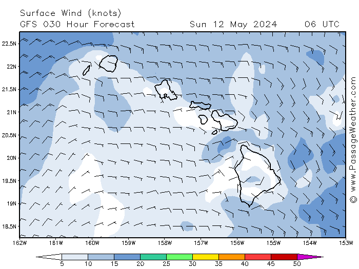
Following the weather here is interesting. Because the Hawaiian Islands sit in the middle of the Pacific Ocean, they are affected by the trade winds that blow from east to west and vary in intensity, based on the position of the Pacific High. As a result, the eastern sides of the Hawaiian Islands are constantly exposed, while the western sides are protected. Additionally, when the strong trades blow, the channels between the islands experience a strong funneling effect - combined with high seas when the wind-waves piggy-back on the ocean swell.
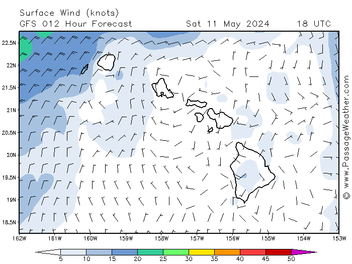
Getting to Maui from Hilo can be challenging until the trades have calmed down. Hilo is the only anchorage on the east side of the Big Island and it is in the middle. The next anchorage is 70 miles on the eastern side of the northern tip and only has room for a couple of boats. From there, it is another 40+ miles across the Alenuihaha Channel to a leeward anchorage on Maui. Although there have been breaks in the strong winds over the last couple of weeks, they haven’t been long enough to make this a pleasant passage. However, according to Passage Weather and other sources, over the next few days the Pacific High will move down toward Hawaii and bring calmer conditions. Our plan is to leave Hilo tomorrow, skip the northern anchorage, and sail directly to Maui. It should take us about 24 hours to get there and we hope to stay for a few days before continuing on to Honolulu.
Although we have spent most of our time here touring around we have also had the chance to do some socializing with the other cruisers here. We’ve had potlucks and Happy Hours at the picnic table and we’ve also gone out to dinner together. We’ve tried more local beers and watched movies we’ve traded with each other.

Cruising line-up, Radio Bay

Barbara, Craig, Doug, Frank, John, Danielle, a couple from Berkley, John's brother, Skip and Jim

Johannica & Jan from Witte Raaf celebrate the crossing with us

Skip on Dolphin and Jane off Midnight Blue in the background
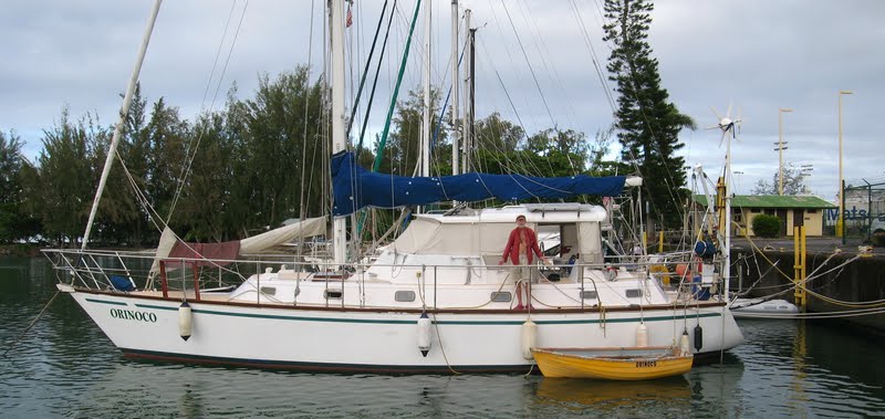
Jim, from Victoria, aboard Orinoco

The Dutch ship, Witte Raaf

Doug discovers a different Mauna Loa!
We've also had a chance to get some work done on the boat.

Cleaning up the auto pilot and the helm
We will have many happy memories of our time here.

The cruise ship comes in every Tuesday
No comments:
Post a Comment