
Wednesday, June 29, 2011
Leaving Hawaii
Ka'sala and her crew will leave Honolulu mid morning today. The winds and seas are looking great for leaving Hawaii and hopefully will continue throughout the passage. We expect to be in the Straits of Juan de Fuca sometime around July 21. Remember you can follow our passage through the Pacific Seafarers' Net or Yotreps as I described in the previous entry. We really appreciate your support and know your positive thoughts help us along the way. Aloha!
Sunday, June 26, 2011
Oahu and Preparing for Crossing the Pacific (yet again)
Where does the time go? We’ve been in Honolulu for a little over a week and in less than a week we will be embarking on the next big leg home . It seems like only yesterday we touched land in Hilo after 23 days at sea. Will it seem the same when we arrive back on the mainland? I have a terrible feeling that one day, very soon, I will look up from my desk and remember this entire year aboard Ka’sala as a dream that happened to someone else – at least I’ll have this blog to remind me!
We have continued work on Ka’sala to prepare for the voyage. Doug’s been up the mast twice to inspect the rig – in great shape – and to remove and replace the trilight and wind indicator. We installed an LED bulb in the light to help reduce our electrical draw. The indicator has always been sticky and a smart cleaning should make it work a lot better. Doug has added a second antenna which has greatly improved our radio reception. We've replaced our batteries so should not have the same electrical challenges we had on our way here. Ray, the young lad from Freedom, cleaned our hull and scraped off the barnacles that were starting to collect. A smooth bottom will make for faster passage.
![]()
We’ve bought an Aqualink to add to our emergency equipment. (For more info: http://www.forgesurvivalsupply.com/index2.php?page=shop.product_details&flypage=tpflypage.tpl&product_id=217&category_id=23&option=com_virtuemart&Itemid=3)

We’ve topped up our diesel, refilled the propane and cleaned out lockers. Cold weather clothes have been brought out to air. I’ve done the first dry/canned provisioning and have prepared my last minute lists. Our crew, Tony, joined us for a couple days before continuing on to the Big Island. He will rejoin us Monday for the final preparations before continuing on.
![]()
We’re almost ready to cross the Pacific again.
The weather continues hot and humid, but comfort is saved by the continuous breeze that flows down out of the mountains that frame this city. Most days we have brief misty rain showers that have us scrambling to close up the port lights, but also reward us with spectacular rainbows.
![]()
![]()
![]()
![]()
Our fans are running constantly below and, while I was sick, I was sure I would spontaneously combust with the combination of the climate, my temperature and hot flashes! I know I will miss this weather when we are back in Comox, but some days I really long for winter and imagine myself crawling into the yacht club’s ice machine. Doug has taken pity on me and replaced most of the fans. Now, instead of squealing and clattering, I am spoiled by the smooth sounds of white noise.
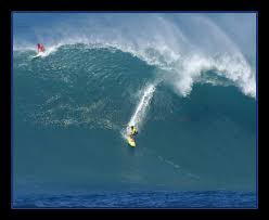
One day we were told by Chris, the club manager, we would have to move off the Aloha dock because Honolulu was expecting a big southern swell to hit the coast later in the day. He was worried about the strength of the dock after it had been damaged in the March tsunami. As it turned out we stayed put and Sequoia was moved to the other end. We had been told that when these big swells come in they break across the entrance to the harbour, so we decided to go have a look. We strolled out to the breakwater and watched in amazement as surfers crested the waves between the entrance bouys. No one in their right mind would leave or come in to the harbour that day!
![]()
![]()
![]()
It hasn’t been all work and no play. Apart from a couple slow days nursing a cold, we’ve been out and about this windy city. Because the days have been very hot, so we have tried to do our walking at the beginning and end of the days. One evening, after dinner in the cockpit (a real pleasure now our barbeque is fixed!), we headed off toward Waikiki.
![]()
![]()
We only have to transverse a parking lot before we are by the Hilton Lagoon and a paved walk that stretches pretty much unbroken all the way to surfing legend, Duke Kahanamoku”s statue.

The pathway winds its way through hotel gardens and pools lit by tikki lanterns on one side with the sound of pounding surf on the other - even in the dark people are frolicking in the water.


We wound our way around to the street and returned home through avenues of designer shops and boutiques. It was interesting to people watch as we went along, feeling quite scruffy and out-of-place in our cruiser’s uniform of baggy shorts and t-shirts.


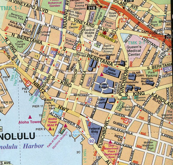
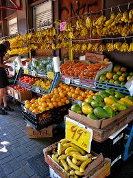
On another day we took the bus to Chinatown. This area, right downtown, is about 8 blocks square and is filled with little shops and markets.
The fresh vegetables and fruit gleam on the stands and the catfish are still squiggling in the fish markets. Girls poke blue crabs to keep them lively and little kids stare at the giant frogs in the aquariums.

Duck, chicken and pig are readily available, and all around, is buzz and chatter. Your eyes see accents of red, lots of elderly ladies with their little shopping bags, housewives hurrying along with babies, and older men gambling by the river.

The buildings here are all two and three stories high and somewhat dilapidated, surrounded by high rise offices. There are the requisite, questionable alleyways and a tiny red light district worn from a century or more of continuous use.

When Barbara and I were there - scouting for fresh and less expensive provisions we even managed to take in Yum Cha at Mei Sum. Mmmmmmm - love those little dumplings!


The ghosts of the early Chinese may be still be in the shadows, but today the streets are filled with people from many walks of Asian life.
We rented a Honda Civic for our last week (booked through Hotwire and hired from Enterprise) which has given us a great deal of mobility. One day we decided to circumnavigate the island.

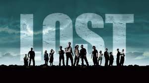
We headed east past Diamond Head and through the wealthy Kahana neighbourhood where Doris Duke has her famous middle-eastern inspired mansion. Farther, around Koko Head we were delighted to recognize scenes from the Lost series.

Stopping at the blowhole lookout by Sandy Beach we saw a tiny private beach where the famous love scene with Debra Kerr and Burt Lancaster in From Here to Eternity was filmed.
![]()
On the other side was some decent surf where dare devil surfers strut their stuff.
We continued on to Kailua, a beautiful town with an incredible backdrop of folded mountains that apparently cascade with waterfalls in rainier seasons. Several more scenes from Lost were filmed at the nearby Kualoa Ranch. (as well as Jurassic Park and Godzilla)
![]()
![]()
![]()
![]()
We stopped at a little park near Waimanolo and wondered what it would be like to live in such a gorgeous place.
![]()
Later, we continued north, passing by many small beach towns until we came to Kahuku where we stopped for a delicious lunch of macademia/coconut shrimp and salad. (Imagine a large shrimp deep-fried in a macaroon and you get the idea – definitely NOT for the waist conscious!)

The owner of the Kahuku Grill was quite taken by the idea we had sailed to Hawaii and joined us after lunch. He brought with him a gift of some of his wife’s banana bread that really distracted us from the conversation. It turned out this area of Oahu is the home of many Hawai’in Mormons and ta branch of the Hawaiian Brigham Young University. Our host, Art, is a Mormon surfer who was proud to tell us about his life on the island with his seven sons and 5 daughters-in-law.
![]()
Feeling very stuffed, we crammed ourselves back into the car and rounded the northern end of Oahu and along some of the most famous surfing beaches in the world with names such as Pipeline, Shark’s Cove and Backyards. The day we were there the seas were flat, but apparently in the winter the surf around Waimea is absolutely amazing. We have seen videos of these athletes on the waves that are hard to believe. We’ve been told that in addition to being super-fit, surfers also have to be able to hold their breath for the long periods of time they spend under the waves. Not a sport for the feint of heart!

Leaving the surf beaches behind, we continued on along the Farrington Highway to Molule’ia Beach where the beach scenes from Lost were shot. We saw no evidence of sets, but the stunning scenery was even more awesome than portrayed in the TV series. We looked, but we didn’t see any black smoke.
![]()
We retraced our route to Hale’iwa, then headed inland through fields and fields of sugar cane and pineapple arriving at Schofield Army base.

We had read that we might be able to transit the base through Lyman Gate to follow Highway 780 through the Kolekole Pass to the leeward side of Oahu. We were able to get very close to this famous pass - where the Japanese Zeros traversed to make their surprise attack on Pearl Harbour in 1941 - but could not continue past a locked gate. Too bad.

Once again, we doubled back on our route and continued south to Honolulu, passing multiple gated communities, golf courses and suburbs before reaching the freeway. By the time we got back to Ka’sala we were pretty tired.
Being docked at the Ala Wai is pretty cool. Every day we watch the young sailors in their dinghies. There is a lot of sailboat traffic – catamarans, mono-hulls, and fishing boats of all sizes come and go. However, one of the most remarkable events is the legion of fit people of all ages paddling various types and sizes of outrigger canoes. They are most often seen in the early morning and evening – either honing their skills and working out, or racing each other. It’s quite a sight! (This series of photos compliments of Barbara)
![]()
![]()
![]()
![]()
However, the days of R&R are coming to an end. We’ve been watching the weather closely and it looks like the time for us to leave will be Wednesday (June 29) or Thursday (June 30) of this week. We may, or may not, stop at Hanalei Bay on Kaua’io n our way north – depending on weather and seas. Traditionally cruisers have anchored there to wait for a weather window and enjoy the last few days of rest and sunshine before beginning the northward passage. We have heard there will be about 6 boats who will be making the passage around the same time as us and many of them will stop there before continuing.
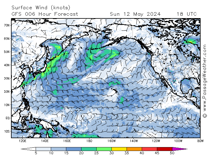
We will be participating in a casual morning net with them as we make our progress across the Pacific, as well as checking in to the Pacific Seafarer’s Net as we did on our crossing to Hawaii. We hope you will follow us on Yotreps as we make our way. Knowing there are family and friends thinking of us while we are at sea is a real morale booster for us. All you have to do is check http://www.pacsea.org/ hit on "Current Roll Call" and find the information for VE7KSL. If you scroll to the bottom of this page and insert our call sign (VE7 KSL) and hit submit, you will automatically be taken to our position map on Yotreps. You can also track the weather we will encounter by going to http://www.passageweather.com/ and clicking on "North Pacific Ocean". I will post once more the day we leave Honolulu. As before, we will not be able to send or receive email, so the next entry after that will not be until we arrive on the mainland.
The passage home is approximately 2500 nautical miles and we expect it will take us 21 to 28 days. A lot of our planning will depends on the position of the Pacific High. The usual sailing profile, from Hawaii to the Straits of Juan de Fuca, is to go straight north from Hawaii, taking the easterly flow of the trade winds on the beam until reaching approximately 30 degrees north. There, the wind should start moving in a clockwise direction under the influence of the High. At this point, windless conditions can occur, forcing cruisers to motor. (we have about 500 nautical miles of fuel) At about 40 degrees north the westerlies should kick in, allowing the cruiser to follow an easterly course. These winds give similar conditions to the trade winds that flow between Mexico and Hawaii, but come from the opposite direction. Westerlies can be boisterous and, sometimes, really strong winds can blow at these latitudes. However, during the summer months the Pacific High generally forces these hardy winds higher north making this the perfect time of the year to make the passage. We plan to make our landfall on the US side of Juan de Fuca,. We may land at Neah Bay (48.21 N, 124.41 W) or Port Angeles (48.0N, 123.5 W), before continuing on to Port Townsend (48.1N, 122.7W. (The latitude and longitude of Honolulu is 21.16N, 157.49 W.)
![]()
We have continued work on Ka’sala to prepare for the voyage. Doug’s been up the mast twice to inspect the rig – in great shape – and to remove and replace the trilight and wind indicator. We installed an LED bulb in the light to help reduce our electrical draw. The indicator has always been sticky and a smart cleaning should make it work a lot better. Doug has added a second antenna which has greatly improved our radio reception. We've replaced our batteries so should not have the same electrical challenges we had on our way here. Ray, the young lad from Freedom, cleaned our hull and scraped off the barnacles that were starting to collect. A smooth bottom will make for faster passage.

Robert, Kaylita and Ray from Freedom (in background)
We’ve bought an Aqualink to add to our emergency equipment. (For more info: http://www.forgesurvivalsupply.com/index2.php?page=shop.product_details&flypage=tpflypage.tpl&product_id=217&category_id=23&option=com_virtuemart&Itemid=3)
Aqualink Emergency Beacon
We’ve topped up our diesel, refilled the propane and cleaned out lockers. Cold weather clothes have been brought out to air. I’ve done the first dry/canned provisioning and have prepared my last minute lists. Our crew, Tony, joined us for a couple days before continuing on to the Big Island. He will rejoin us Monday for the final preparations before continuing on.

We’re almost ready to cross the Pacific again.
The weather continues hot and humid, but comfort is saved by the continuous breeze that flows down out of the mountains that frame this city. Most days we have brief misty rain showers that have us scrambling to close up the port lights, but also reward us with spectacular rainbows.

(photo by Barbara)

(photo by Barbara)

Pot of Gold

View from our cockpit
One day we were told by Chris, the club manager, we would have to move off the Aloha dock because Honolulu was expecting a big southern swell to hit the coast later in the day. He was worried about the strength of the dock after it had been damaged in the March tsunami. As it turned out we stayed put and Sequoia was moved to the other end. We had been told that when these big swells come in they break across the entrance to the harbour, so we decided to go have a look. We strolled out to the breakwater and watched in amazement as surfers crested the waves between the entrance bouys. No one in their right mind would leave or come in to the harbour that day!

Note the far end of the breakwater to the right - I tried to include the buoys in the pictue but they are hidden behind the break.

Dadadadadundah Dadadadundahdah - Hawaii 5-0 here we come!

Dual outrigger just outside of the breakwater
It hasn’t been all work and no play. Apart from a couple slow days nursing a cold, we’ve been out and about this windy city. Because the days have been very hot, so we have tried to do our walking at the beginning and end of the days. One evening, after dinner in the cockpit (a real pleasure now our barbeque is fixed!), we headed off toward Waikiki.

The Hilton Village Lagoon is at the end of the parking lot - Diamond Head in the distance

Inviting boardwalk follows the beach at Waikiki in fits and starts
The "Duke" - this statue is contraversial because the famous surfer is facing the shops of Waikiki instead of the surf
Every Friday night the Hilton explodes a phenomenal number of fireworks - just for the fun of it!
We wound our way around to the street and returned home through avenues of designer shops and boutiques. It was interesting to people watch as we went along, feeling quite scruffy and out-of-place in our cruiser’s uniform of baggy shorts and t-shirts.
And we didn't look much better after it rained!
On another day we took the bus to Chinatown. This area, right downtown, is about 8 blocks square and is filled with little shops and markets.
Duck, chicken and pig are readily available, and all around, is buzz and chatter. Your eyes see accents of red, lots of elderly ladies with their little shopping bags, housewives hurrying along with babies, and older men gambling by the river.
The buildings here are all two and three stories high and somewhat dilapidated, surrounded by high rise offices. There are the requisite, questionable alleyways and a tiny red light district worn from a century or more of continuous use.
When Barbara and I were there - scouting for fresh and less expensive provisions we even managed to take in Yum Cha at Mei Sum. Mmmmmmm - love those little dumplings!
We rented a Honda Civic for our last week (booked through Hotwire and hired from Enterprise) which has given us a great deal of mobility. One day we decided to circumnavigate the island.
We headed east past Diamond Head and through the wealthy Kahana neighbourhood where Doris Duke has her famous middle-eastern inspired mansion. Farther, around Koko Head we were delighted to recognize scenes from the Lost series.
(the lighthouse for example).
Stopping at the blowhole lookout by Sandy Beach we saw a tiny private beach where the famous love scene with Debra Kerr and Burt Lancaster in From Here to Eternity was filmed.
Can you imagine them on the beach?
On the other side was some decent surf where dare devil surfers strut their stuff.
![]()

Sandy Beach Park - not for swimming!
We continued on to Kailua, a beautiful town with an incredible backdrop of folded mountains that apparently cascade with waterfalls in rainier seasons. Several more scenes from Lost were filmed at the nearby Kualoa Ranch. (as well as Jurassic Park and Godzilla)

Mountains behind the Kualoa Ranch

Kualoa Ranch mountains

The landscape sets the mood and is always one of the main characters in any film made in Hawaii
On the other side is a large bay, protected by reefs and sandbars. 
Is this a character from Lost?
We stopped at a little park near Waimanolo and wondered what it would be like to live in such a gorgeous place.

Could you live here?
Coconut/Macademia Shrimp

Cool dude at the Kahuku Grill
Feeling very stuffed, we crammed ourselves back into the car and rounded the northern end of Oahu and along some of the most famous surfing beaches in the world with names such as Pipeline, Shark’s Cove and Backyards. The day we were there the seas were flat, but apparently in the winter the surf around Waimea is absolutely amazing. We have seen videos of these athletes on the waves that are hard to believe. We’ve been told that in addition to being super-fit, surfers also have to be able to hold their breath for the long periods of time they spend under the waves. Not a sport for the feint of heart!
Surfing Waimea - the photos speak for themselves
Leaving the surf beaches behind, we continued on along the Farrington Highway to Molule’ia Beach where the beach scenes from Lost were shot. We saw no evidence of sets, but the stunning scenery was even more awesome than portrayed in the TV series. We looked, but we didn’t see any black smoke.

Molule’ia Beach
We retraced our route to Hale’iwa, then headed inland through fields and fields of sugar cane and pineapple arriving at Schofield Army base.
Sugar cane fields cover central Oahu
We had read that we might be able to transit the base through Lyman Gate to follow Highway 780 through the Kolekole Pass to the leeward side of Oahu. We were able to get very close to this famous pass - where the Japanese Zeros traversed to make their surprise attack on Pearl Harbour in 1941 - but could not continue past a locked gate. Too bad.
Kolekole Pass
Once again, we doubled back on our route and continued south to Honolulu, passing multiple gated communities, golf courses and suburbs before reaching the freeway. By the time we got back to Ka’sala we were pretty tired.
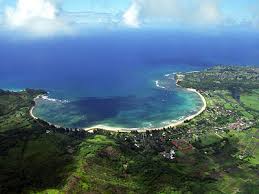
Being docked at the Ala Wai is pretty cool. Every day we watch the young sailors in their dinghies. There is a lot of sailboat traffic – catamarans, mono-hulls, and fishing boats of all sizes come and go. However, one of the most remarkable events is the legion of fit people of all ages paddling various types and sizes of outrigger canoes. They are most often seen in the early morning and evening – either honing their skills and working out, or racing each other. It’s quite a sight! (This series of photos compliments of Barbara)

These paddlers are so focussed - one time one of them hit his head on our dinghy!

We see lots of teambuilding activities using these outriggers

This is hard work - the paddlers fly down the channel, but have to work against current and wind on their return

They're certainly fit!
This gorgeous bay will be hard to resist!
We will be participating in a casual morning net with them as we make our progress across the Pacific, as well as checking in to the Pacific Seafarer’s Net as we did on our crossing to Hawaii. We hope you will follow us on Yotreps as we make our way. Knowing there are family and friends thinking of us while we are at sea is a real morale booster for us. All you have to do is check http://www.pacsea.org/ hit on "Current Roll Call" and find the information for VE7KSL. If you scroll to the bottom of this page and insert our call sign (VE7 KSL) and hit submit, you will automatically be taken to our position map on Yotreps. You can also track the weather we will encounter by going to http://www.passageweather.com/ and clicking on "North Pacific Ocean". I will post once more the day we leave Honolulu. As before, we will not be able to send or receive email, so the next entry after that will not be until we arrive on the mainland.
The passage home is approximately 2500 nautical miles and we expect it will take us 21 to 28 days. A lot of our planning will depends on the position of the Pacific High. The usual sailing profile, from Hawaii to the Straits of Juan de Fuca, is to go straight north from Hawaii, taking the easterly flow of the trade winds on the beam until reaching approximately 30 degrees north. There, the wind should start moving in a clockwise direction under the influence of the High. At this point, windless conditions can occur, forcing cruisers to motor. (we have about 500 nautical miles of fuel) At about 40 degrees north the westerlies should kick in, allowing the cruiser to follow an easterly course. These winds give similar conditions to the trade winds that flow between Mexico and Hawaii, but come from the opposite direction. Westerlies can be boisterous and, sometimes, really strong winds can blow at these latitudes. However, during the summer months the Pacific High generally forces these hardy winds higher north making this the perfect time of the year to make the passage. We plan to make our landfall on the US side of Juan de Fuca,. We may land at Neah Bay (48.21 N, 124.41 W) or Port Angeles (48.0N, 123.5 W), before continuing on to Port Townsend (48.1N, 122.7W. (The latitude and longitude of Honolulu is 21.16N, 157.49 W.)

Here's the proof - the Pot of Gold is in Ala Moana Beach Park, Honolulu
Friday, June 17, 2011
From Maui to Molokai and on to Honolulu
Leaving Lahaina, Maui, was not an easy thing to do. It is a gorgeous place with friendly people, a small town with plenty of culture, a climate both warm and inviting, a place surrounded by mountains and ocean. The connections we made with the locals made us feel we could make a place like Lahaina home. But our other home, far to the north, was beckoning and the tradewinds were promising to increase in a few days so, based on our refreshing sail from the Big Island in supposedly “light” tradewinds, we decided to leave earlier than we had planned.
![]()
The first 3 hours we motor sailed into light winds, but as we got further into the channel, we noticed white caps in the distance. NOAA reports had expressed winds of 15 knots, seas of 7 feet – an easy sail. However, when we crossed the wind line we were plunged immediately into 20 knot winds increasing to 25.
![]()
By the time we arrived at Lono Harbour, we had seen winds gusting over 30 knots with 8 foot, confused, accordion waves. Luckily the wind was on our starboard quarter and we ran along under double reefed main all the way on very exhilarating surf. We had been told to be concerned about the channel, and the winds were strong there, but we hadn’t taken into account the acceleration effect of the eastern trades along the steep south shore of Molokai. Later I read a description of the Transpac Race between Los Angeles and Honolulu - one of the advertised challenges is the final sail along Molokai before reaching the finish line - like a hill at the end of a marathon. These were famously challenging conditions. I, for one, was very glad to see the welcoming breakwaters of Lono as they appeared in the late afternoon.
![]()
Lono Harbour is interesting. The breakwaters had been built in the late 50’s to accommodate tugs and barges as they loaded up with soil and sand for the Waikiki waterfront on Oahu. In 1975 the government made it illegal to remove the aggregates and the harbour was abandoned.
![]()
All that remains is a broken down pier and an excellent mud holding basin for anchoring. There are no houses, the only inhabitant being Chuck, an older man living on a catamaran and fixing up an old Spencer 35 for future adventures.
![]()
There is a broken cliff face and, on the other side of the breakwater, a sandy beach.
![]()
There is a dirt road that connects Lono to the more urbanized eastern side of Molokai. We dropped our anchor in 8 meters and let out 30 meters of chain. The wind could still be felt inside, but the water was flat. It didn’t take us long to don bathing suits and dive in for a refreshing swim.
![]()
We spent two nights there and noticed that the winds seemed to weaken in the early morning hours, so we decided to time our passage to Oahu – and across the Kaiwi Channel – to accommodate these calmer conditions. We got it right because we left at 5:30 and enjoyed a 6 knot run in front of 20 knot winds all the way to Honolulu. We sailed under a full yankee and Ka’sala’s helm was as light as a feather. The sea state was confused, steep and increased as we approached Oahu. Ka’sala and crew took it all very well, admiring the translucent crests of the highest waves as we surfed down them at 7 and 8 knots in brilliant sunshine. Later, when Sequoia arrived at Honolulu they described their passage as even more exciting with winds gusting at 41 knots and seas even higher. Sailing in Hawaii is not for the faint of heart!
![]()
Once we cleared Diamond Head, everything calmed down considerably and we were able to enjoy gazing at the Wakiki waterfront as we glided by.
![]()
We were absolutely amazed at the clarity of the water and, at one point, Doug said: Look down! I could see a big patch of white sand and we were in 20 meters of water. Wow! A few minutes later I looked back to see a white submarine surfacing. OMG! We had motored right over it and we wondered what kind of safety precautions this tourist “view the reef” business incorporated. There were numerous catamarans and other pleasure craft about. As we got closer to shore we could see the surf breaking and crested with the ubiquitous surfers. It took us a bit of searching to pick out the bouys showing the entrance to the Ala Wai, but once locked on we just scooted through the reef and into the harbour.
![]()
First we tied up to the fuel dock to buy our first diesel since Puerto Vallarta – 40 US gallons - $180.00 worth. I guess that is cheaper than flying from the mainland to Honolulu!
![]()
A few minutes later we were tied to the Aloha Dock, in front of Witte Raaf, at the Hawaii Yacht Club.
![]()
We were welcomed by the manager, Chris, who came aboard to take all our information, then led us on a tour of the club. It was obvious to us he takes pride in the facility. We met a number of people, a couple cruisers passing through, and several yachties who live on their boats nearby and use the club, as Chris described, as their “living room”. Everyone was very warm and friendly, welcoming us to Honolulu and offering assistance if we needed it. (http://www.hawaiiyachtclub.org/) (Our profile in their newsletter: http://www.hawaiiyachtclub.org/facilities/aloha-dock.html)
The club is very active and has great facilities. Upstairs is a bar and restaurant which flows into wrap-around decks overlooking the ocean. Live music happens on the weekends and there is a dance floor. Downstairs is for the yachties. There is a large gathering room full of tables and chairs, a library, washrooms with excellent showers, a fully equipped kitchen and another bar. The sliding glass doors lead to a grassy area with outdoor seating and barbeques. The slips surround the club and the Aloha dock is right in front.
![]()
What impressed us the most upon arriving was the vital young sailors' program. We watch many happy kids in little sailboats learning the ropes in the little basin in front. Considering the winds that funnel through the hills and tall building behind, this must be the training ground for future top-notch sailors!
![]()
![]()
![]()
There are race nights and regular sailing events. In fact, the club is currently in the throes of preparing for arrival of the Transpacific Racers from Los Angeles.

The first night we took advantage of the facilities and enjoyed a nice dinner on the upper deck with Jan and Janneke from Witte Raaf, as well as their crew, Guisse. We were lucky to catch them as they were to begin their passage to Alaska a couple days later.
![]()
We had heard from Sequoia and knew they would be joining us in a day or two. Freedom, a boat we had met in Lahaina and again in Lono, arrived a day later. Robert, Kalita and young friend, Ray will be leaving for the mainland around the same time as Sequoia and us. We also learned that three other boats had left within the previous few days to begin the passage north. Looks like we won’t be alone when we cross the Pacific one more time!
Over the next couple weeks we will be busy getting Ka’sala ready for the return voyage. There are chandleries and marine stores here, so Doug has made up his shopping lists. He wants to refine the preventer system he has created and add another antenna for our radios. By installing the second antenna we will have a back-up to the system already in place, but additionally we will be able to replace the masthead trilight with an LED bulb - easing the strain on our electrics. We have ordered 2 deep-cycle batteries to replace the batteries we bought in Mexico which didn't work out. We are expecting Tony, our crew, to join us the last week in June, so we want to make sure he will be comfortable aboard.
We hope to have time to do some sightseeing as well. There is certainly a lot to see and do in this vibrant place. In the meantime, we will try to enjoy our last days in the tropics resting up for the next 2500 mile passage. Aloha!
![]()

Leaving Lahaina
After breakfast on Sunday, June 12, we slid out of the Lahaina boat harbour intending to go to Honolua Bay at the north western tip of Maui. We had been told that Honolua was a great anchorage and an excellent jumping off place to cross the Pailolo Channel for Molokai Island. Sequoia had gone before us and reported it a good anchorage in sand around coral, with lots of tourist activity during the day, but quiet at night. However, when we were a couple miles off Lahaina, we had a change of mind. Why go north, just to go west? The winds seemed favourable, so we decided to sail directly for Lono Harbour on Molokai – the destination we planned to go to the following day.

The rugged shoreline of Molokai
By the time we arrived at Lono Harbour, we had seen winds gusting over 30 knots with 8 foot, confused, accordion waves. Luckily the wind was on our starboard quarter and we ran along under double reefed main all the way on very exhilarating surf. We had been told to be concerned about the channel, and the winds were strong there, but we hadn’t taken into account the acceleration effect of the eastern trades along the steep south shore of Molokai. Later I read a description of the Transpac Race between Los Angeles and Honolulu - one of the advertised challenges is the final sail along Molokai before reaching the finish line - like a hill at the end of a marathon. These were famously challenging conditions. I, for one, was very glad to see the welcoming breakwaters of Lono as they appeared in the late afternoon.

Entrance to Lono Harbour looking out from the anchorage - I was too busy to take the picture coming in!
Lono Harbour is interesting. The breakwaters had been built in the late 50’s to accommodate tugs and barges as they loaded up with soil and sand for the Waikiki waterfront on Oahu. In 1975 the government made it illegal to remove the aggregates and the harbour was abandoned.

Cliff at the base of the harbour - broken piers at the water's edge

Chuck's Place
There is a broken cliff face and, on the other side of the breakwater, a sandy beach.

Sandy beach on the other side - notice the marker to the right (there is another behind it) - when approaching the harbour you line them up for an easy entrance through the coral
There is a dirt road that connects Lono to the more urbanized eastern side of Molokai. We dropped our anchor in 8 meters and let out 30 meters of chain. The wind could still be felt inside, but the water was flat. It didn’t take us long to don bathing suits and dive in for a refreshing swim.

Freedom at anchor in Lono Harbour
We spent two nights there and noticed that the winds seemed to weaken in the early morning hours, so we decided to time our passage to Oahu – and across the Kaiwi Channel – to accommodate these calmer conditions. We got it right because we left at 5:30 and enjoyed a 6 knot run in front of 20 knot winds all the way to Honolulu. We sailed under a full yankee and Ka’sala’s helm was as light as a feather. The sea state was confused, steep and increased as we approached Oahu. Ka’sala and crew took it all very well, admiring the translucent crests of the highest waves as we surfed down them at 7 and 8 knots in brilliant sunshine. Later, when Sequoia arrived at Honolulu they described their passage as even more exciting with winds gusting at 41 knots and seas even higher. Sailing in Hawaii is not for the faint of heart!

First glimpse of Oahu
Once we cleared Diamond Head, everything calmed down considerably and we were able to enjoy gazing at the Wakiki waterfront as we glided by.

Approaching Diamond Head - Honolulu in the background
We were absolutely amazed at the clarity of the water and, at one point, Doug said: Look down! I could see a big patch of white sand and we were in 20 meters of water. Wow! A few minutes later I looked back to see a white submarine surfacing. OMG! We had motored right over it and we wondered what kind of safety precautions this tourist “view the reef” business incorporated. There were numerous catamarans and other pleasure craft about. As we got closer to shore we could see the surf breaking and crested with the ubiquitous surfers. It took us a bit of searching to pick out the bouys showing the entrance to the Ala Wai, but once locked on we just scooted through the reef and into the harbour.

Waikiki - red bouy to the right is off Diamond Head
First we tied up to the fuel dock to buy our first diesel since Puerto Vallarta – 40 US gallons - $180.00 worth. I guess that is cheaper than flying from the mainland to Honolulu!

Entrance to the Ala Wai looking out - fuel dock to the left
A few minutes later we were tied to the Aloha Dock, in front of Witte Raaf, at the Hawaii Yacht Club.

Ka'sala on the Aloha Dock at the Hawaii Yacht Club
The club is very active and has great facilities. Upstairs is a bar and restaurant which flows into wrap-around decks overlooking the ocean. Live music happens on the weekends and there is a dance floor. Downstairs is for the yachties. There is a large gathering room full of tables and chairs, a library, washrooms with excellent showers, a fully equipped kitchen and another bar. The sliding glass doors lead to a grassy area with outdoor seating and barbeques. The slips surround the club and the Aloha dock is right in front.

The Hawaii Yacht Club
What impressed us the most upon arriving was the vital young sailors' program. We watch many happy kids in little sailboats learning the ropes in the little basin in front. Considering the winds that funnel through the hills and tall building behind, this must be the training ground for future top-notch sailors!

Intently following the lesson

Getting ready to launch

In the harbour - Honolulu skyline in background
The first night we took advantage of the facilities and enjoyed a nice dinner on the upper deck with Jan and Janneke from Witte Raaf, as well as their crew, Guisse. We were lucky to catch them as they were to begin their passage to Alaska a couple days later.

Guisse, Jan and Janeke wave Aloha! as they leave Honolulu - next port of call: Sitka, Alaska
We had heard from Sequoia and knew they would be joining us in a day or two. Freedom, a boat we had met in Lahaina and again in Lono, arrived a day later. Robert, Kalita and young friend, Ray will be leaving for the mainland around the same time as Sequoia and us. We also learned that three other boats had left within the previous few days to begin the passage north. Looks like we won’t be alone when we cross the Pacific one more time!
Over the next couple weeks we will be busy getting Ka’sala ready for the return voyage. There are chandleries and marine stores here, so Doug has made up his shopping lists. He wants to refine the preventer system he has created and add another antenna for our radios. By installing the second antenna we will have a back-up to the system already in place, but additionally we will be able to replace the masthead trilight with an LED bulb - easing the strain on our electrics. We have ordered 2 deep-cycle batteries to replace the batteries we bought in Mexico which didn't work out. We are expecting Tony, our crew, to join us the last week in June, so we want to make sure he will be comfortable aboard.
We hope to have time to do some sightseeing as well. There is certainly a lot to see and do in this vibrant place. In the meantime, we will try to enjoy our last days in the tropics resting up for the next 2500 mile passage. Aloha!

The sweet smelling plumeria
Subscribe to:
Posts (Atom)