

An earlier eruption of Mauna Loa
The Hawai’ns believe that the goddess Pelehonuamea, affectionately called Pele, lives in the active Halema’uma’a Crater partway down Mauna Loa. When her temper or jealousy flares up, so do the eruptions and the consequent lava flows. There are many stories and legends surrounding these events which remind me of Greek mythology. Whatever the belief, beyond a doubt, this massive volcano is very impressive.

The goddess Pele
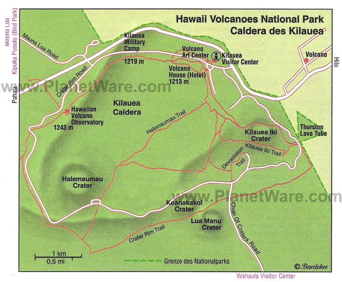
After paying $10.00 at the park gate we checked into the visitor centre.

We watched the films and the most surprising thing we learned was that the Hawai’in Archipelago is still growing. Acres of land are being created on the south end of the big island as the lava flows into the sea, cools and creates more mass. To the south of the big island, and under the sea, is another volcano – Lo’ihi - which is erupting and pushing its way to the surface. Someday it will become the newest Hawai’in island. Each of the islands in this archipelago has gone through this process and the shifting of the earth’s plates has moved them, like a conveyor belt, four inches a year to the northwest.
We returned to the car and continued along the Crater Rim Drive which circles the caldera. The air all around was very misty and was referred to as “vog” – volcanic fog filled with sulfer dioxide. Unfortunately for tourists, this vog has increased in its density in the last few years creating dangerous levels of gases and causing most of the area around the crater to be closed to the public. We were able to stop at the steam vents to see plumes of vapour pour out of fissures and cracks.

The steam rising up from this vent was hot - why are there no spas here?


Steam vents rose all across this field
We walked along a path to the rim of the crater and were able to see right across its expanse. What a sight! My heart rate was definitely high as I looked across this moonscape, imagining the power that lay just below the surface.

Blonde Pele at the side of the cliff - crater in the background
We continued on and stopped at a small outlook which showed the cliffs we had looked over by the steam vents. It was a pretty spooky feeling to know we were just feet from the edge.

From the steam vent viewing area

Looking back to the steam vent viewing area - we were very close to the edge
Further along we came to the Jagger Museum – a small interpretive centre – where we could read more about the volcano and the research it has garnered over the years. On a platform, outside of the building we could get a better look at the crater, but on the day we were there we could only see the smoke rising.


Apparently, if you came at night, you could see the glow of the lava in the smoke. Apparently there had not been an eruption for several months and the last one had been quite small. There was another little gift shop here.

Unfortunately for us, the road also ended here, closed because of the sulphur dioxide gases, and we were forced to retrace our tracks. No spewing rocks, towers of lava or flow for us! We tried to decide if it was a good or bad thing – especially after seeing the footage of eruptions and flow in the films at the visitor centre!
Another option for us was to continue our exploration of the park by driving down the Chain of Craters Road to the sea. This is a 36 mile round trip where, at the halfway point, lava has crossed the road, severing it from continuing on to the south westernmost communities of the big island. Alternatively, if we had brought our hiking shoes and a jacket (it was quite cool), we could have walked through a secondary crater called Kilauea Iki, or chosen from several other trails that wound around the area. We wanted to continue south to Ocean View, so decided to leave these options for another day.
Doug had been in touch with Randy of the Pacific Seafarer’s Net and we were heading to Ocean View, where he lives, to have lunch with him and his wife, Lynn.

Randy
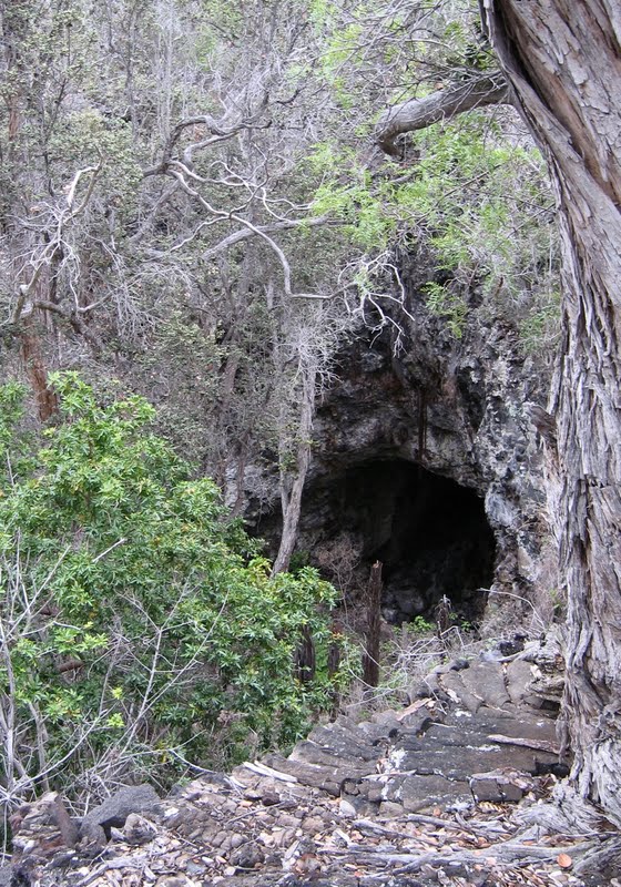
Lava tube on Randy's amazing property
After lunch at the local bakery, Randy showed us around his unique property and a tour of his radio workshop.


In the late afternoon we headed back to Hilo. We decided to check out the extreme south point of the island and followed a twisty, windy road through pastureland that gradually sloped down to the sea.

The rugged most southern point in the US

These windmills always give me the science fiction creeps
The road deteriorated into a potholed track as we approached the cliffs at the end. There were quite a few cars down there and we could see kids jumping off the cliffs and climbing back up rope ladders to do it again. The water was turquoise clear at the southern most point of the United States.

Cliff diving in Hawaii
We continued along the pocked road which seemed to branch out all over the place. When we saw the foundations of old buildings we began to realize that the area must have once been some kind of military base. (We later found out it was a Pacific Missile Range Station that tracked missiles shot from California to the Marshall Islands). We reached the end of the road where there were many more parked cars whose occupants, we later learned, had hiked the 2km or so, to Green Sands Beach, coloured that way because of olivine sand that had eroded from an ancient volcanic cone nearby.
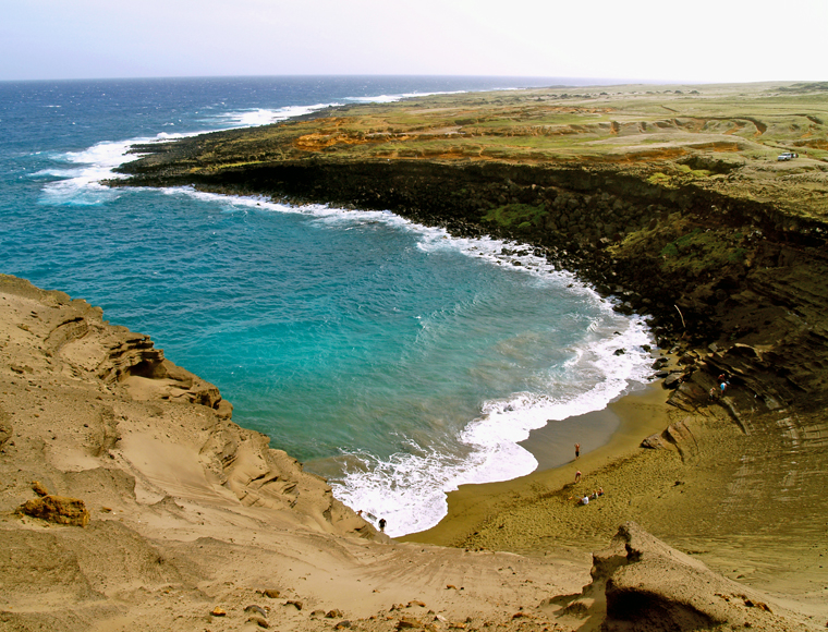
Green Sands Beach, South Point, Hawaii
The day was getting on, so we turned around and retraced our steps, once more, to the highway.
A few miles further, we stopped at Punalu’u – a black sand beach that is apparently famous for basking green sea turtles. We didn’t see any turtles, but were amazed at how BLACK the beach is! There were quite a few local people here picnicking and fishing, as well as tourists strolling the beach.

Now that's a black beach!

Black lava landscape

Happy Birthday, Darlene!
No comments:
Post a Comment