

Silas Crosby and Steve at Potter's Lagoon, BC 2009
John

Meredith, Doug and Steve on the Golden Gate Bridge
Silas Crosby left Comox in late August and sailed non-stop from Neah Bay to San Francisco to arrive mid September. On our first night together we shared champagne to celebrate the first part of our journey and our safe arrival in SF. We were joined by Julie and Paul, another Canadian couple, aboard the lovely wooden hulled, Mia Dos, heading for warmer climes.

Silas Crosby at Potts Lagoon, 2009
Over the next few days Steve, John and Doug explored the Marin Headlands behind Sausalito and I climbed the terraces of Sausalito to enjoy the beautiful architecture and gardens of the houses perched on the hillside. Meredith, clever girl, negotiated a bicycle at a good price, and had wheels to get her around the Bay area.

Sausalito Staircase

Sausalito Mailboxes
One day Steve, Doug, Meredith and I decided to walk into San Francisco from Sausalito across the Golden Gate Bridge. It was a perfect day to do so – warm, no fog for a change. We did take the bus for short distances and ended up in Golden Gate Park to visit the California Academy of Sciences. We were under the mistaken impression it was one of the free days, and were a bit taken back to find it would cost us $30.00 each to visit. So, instead, we continued through the park and into the Haight-Ashbury district once again.

Holding on tight!

Meredith, Doug and Steve at the Golden Gate Bridge

You can't tell, but I was pretty nervous - vertigo supremo - I walked rapidly and hugged the lamp posts all the way across
The Golden Gate Bridge has the dubious privilege of being the most popular place to commit suicide on the entire planet. Although the actual figure isn't known, at least 1200 people were recorded to have died by 2005. Because the currents are so swift beneath the bridge, many suicides are washed out to sea. Police report abandoned cars in parking lots near the bridge as likely suicides, so the actual number is probably much higher. The average jump is one every two weeks and the success rate is 98%. Apparently people travel to the bridge from all over the world to commit this act. Of course, this figure excludes the people who have tried to commit suicide and have been prevented by one means or another. In 2006 over 70 people were talked out of it by the Highway Patrol alone. On many of the lamp posts along the bridge are crisis posters and hot lines for these desperate people.

The city has looked at methods of prevention, but the monetary cost, not to mention the engineering challenges, of rigging up a barrier is phenomenal. However, in 2008 was it decided to suspend a plastic covered, stainless steel net below the bridge at a cost of 40 - 50 million dollars. I found it nerve wracking just to walk across.

It's 245 feet down!
Meredith suggested we go to the famous Magnolia Brew Pub in Haight/Ashbury for a beer and, of course, we couldn’t resist!

This seven-barrel brewpub makes its hand-crafted beer in the basement and proudly advertises their “creativity, independence and tradition”, inspired by the “back-to-the-land, do-it-yourself movement of the 60’s”.

Magnolia's fare

Mmmmmmm, good!

The Grateful Dead at Haight/Ashbury
Things mellowed out after this experience and we continued on our journey with smiles on our faces, down back streets, side streets and little neighbourhoods, all the way to Pier 39 where we caught the Blue & Gold ferry back to Sausalito.

One Sunday afternoon Steve, Doug and I met at the No Name Bar in Sausalito to hear some very entertaining Dixie Jazz. Called Mal Sharpe’s Dixieland Band, this group consisting of clarinet, sax, trombone, trumpet, bass, guitar and drums fired off a few sets of eclectic Dixie, to say the least. Mal Sharpe is a local celebrity, having created a type of man-on-the-street comedy in the 1960’s where he and a fellow conspirator used a hidden camera and asked passersby “an almost plausible question, then proceed(ed) step by step into absurdity until the interviewee is seething." In other words, he likes to annoy and insult people! We saw a bit of this black humour when he made some disparaging remarks about a customer’s wife in the bar that afternoon. I was glad to be hidden around a corner, but did enjoy the music.

Mal Sharpe
I finally found the definitive website for Sausalito and if you ever go there – this is the site to consult: http://www.oursausalito.com/
After a few days it was time to move on again. This time we headed up Raccoon Strait, for Angel Island, which is now a California State Park, and the tiny Ayala Cove. Here, boats can tie up to the dock for the day ($15.00), or pick up a mooring ($30.00) if they intend to spend the night. We picked up a mooring and enjoyed the sunny, warm day as we waited for Silas Crosby to join us. Soon after they arrived, we piled into our dinghies and headed to shore to walk to Mount Livermore, the 240 meter summit of this non-residential island.

Alcatraz and SF from Mount Livermore

Ka'sala and Silas Crosby in Ayala Cove, Tiberon in the background

Angel Island Hiking Trail

Looking to the Ridge at Angel Island
In a combined effort, Doug barbequed some chicken, Meredith made a very tasty peach torte, I put together the fixings and Steve and John provided encouragement and great appetites. What a feast! Later, Silas Crosby returned to Sausalito and we spent a star filled night in the lovely Ayala Cove.

Silas Crosby and Ka'sala rafted in Ayala Cove
Next morning Doug and I rowed ashore again, this time to walk counter-clockwise around the five mile, paved periphery road, to view the old military bases and immigration station and learn more of the island’s history.

Walking Map of Angel Island

Camp Reynolds (photo sourced from: http://photographsofcalifornia.com/ - thank you!)

Abandoned Fort McDowell

The deer are everywhere on Angel Island

On the Angel Island Periphery Road, Alcatraz and SF in distance
During the Cold War a NIKE missile base was established and became obsolete in 1962. All that remains is broken concrete. There was also a quarantine centre built at Ayala Cove and, farther along, an immigration station which served from 1910 to 1940. This station, which became known as the “Ellis Island of the West”, processed over 1 million people of Asian descent in often discriminatory ways. Because of the Chinese Expulsion Act of 1882, some hopeful immigrants spent upwards of 2 years waiting to be admitted to the US. During their sojourn, they were segregated from the other immigrants, as well as the people who worked and lived there. It must have been a lonely, frustrating existence. Nowadays, this station is a National Historical Monument, and the history of the place and what went on there is well documented at the sight. For an incredible photo survey, check out this site: www.english.illinois.edu/.
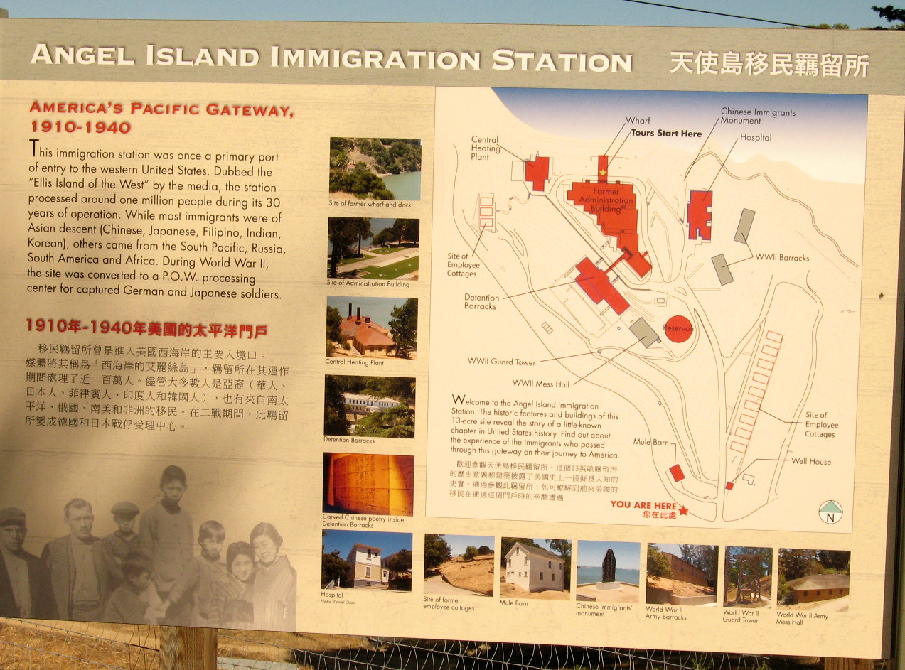
Information - Immigration Station, Angel Island

In its heyday

Immigrant Children, Angel Island
After lunch, we cast off and took advantage of a 10 knot following wind to sail all the way to Vallejo at the mouth of the Napa River at the head of San Pablo Bay. As we penetrated deeper into the Bay, the temperature continued to rise, a two knot current stayed with us until we entered the mouth of the river. After a glorious sail, we arrived at our destination in the early evening.

Marina at Vallejo
I am flattered that you used my photo of Camp Reynolds on your web site. Would you please include a link so people know who the photo belongs to. http://photographsofcalifornia.com
ReplyDeleteThank you.